(CNN) -- Canadian explorer Adam Shoalts knew he was
heading into uncharted territory when he set out on a solo expedition to
explore northeastern Canada's remote Again River.
What the 27-year-old from
Fenwick, Ontario, didn't expect was to find himself hurtling over a
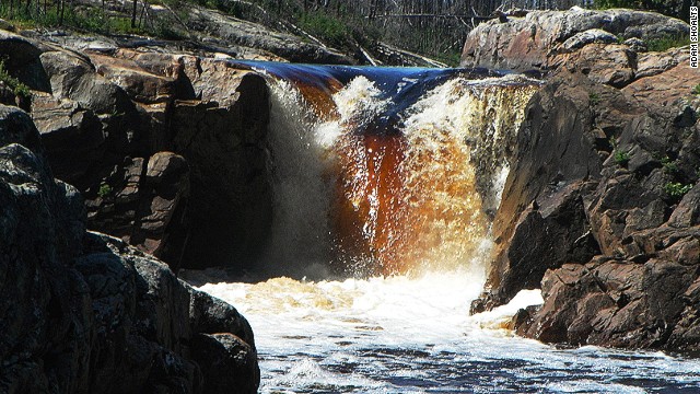
20-foot waterfall that had never been documented -- and then go on to
discover six more waterfalls after fixing his canoe.
The nearly 100-kilometer long Again River is a tributary of Quebec's Harricanaw River, part of Canada's Hudson Bay Lowlands.
It's one of the largest
roadless areas on earth outside Antarctica, says Shoalts, containing
rivers so remote that even today there are a few that have escaped
accurate mapping -- including the Again.
"The expedition was five
years in the making," he says. "Extensive research went into it, looking
through explorers' records, Geological Survey notes, speaking directly
with aboriginal elders."
But his research didn't offer any hints as to the dangers that lay ahead.
Even Google Earth's
low-resolution satellite imagery, all that's available for this remote
part of Canada, is deficient for detecting waterfalls.
"The plan was to explore
the river, record information about flora and fauna, rapids and the
geography in general," he says. "I knew there would be lots of
whitewater rapids, but no one knew that waterfalls existed on the
river."
'Yikes, this is going to be bad!'
With the support of the Royal Canadian Geographical Society,
Shoalts conducted two reconnaissance expeditions to the area (one in
2008 and another in 2009), exploring the wilderness around the Again
River.
But he wasn't able to
canoe the Again, as just getting to the river's isolated headwaters is a
challenge that involves a few days of bushwhacking and creek-hopping.
"In August 2012, I went
back, this time alone, determined to canoe the river no matter what," he
says. "The seven waterfalls were so unexpected and special."
The first waterfall Shoalts found -- before it was too late to go around it -- was 20-feet high.
Of the six he went on to discover, the highest was 40-feet high.
"My first thought when I
realized I was being swept over a waterfall was, 'Wow! What an amazing
discovery! The Geographical Society will be thrilled!" he recalls.
"The second thought was,
'Yikes! This is going to be bad!' I realized I couldn't escape from the
current so I just braced myself for the drop."
Shoalts says he was sucked underwater beneath the fall "for longer than was comfortable."
He resurfaced, out of breath, and spotted his canoe upside down in an eddy near the riverbank.
"I swam to shore,
recovered most of my gear -- except my hat, fishing rod and some
moccasins -- and then set about repairing my canoe.
"Once I got my breath,
that is. It took about an hour and a half to get the canoe back in shape
and ready to continue downriver."
Return to the scene of discovery
This week, Shoalts is heading back to the Again River to continue his work for the Royal Canadian Geographical Society (RCGS).
He'll retrace his route
and photograph, measure and document the precise location of each
waterfall so that they can be added to topographical maps, pending
verification from Spot satellite imagery.
"This expedition is
geographical exploration in the truest sense: Shoalts's work will change
the map of Canada -- a rarity in 21st century exploration," says the
RCGS.
Technology is helping explorers make discoveries in an era when significant finds are incredibly rare.
Most recently, in June of this year, archaeologists announced they'd found a huge medieval city buried beneath impenetrable jungle on a remote mountain in Siem Reap, Cambodia.
It wouldn't have been discovered but for the help of a remote sensing laser instrument.
Though Shoalts says gadgets are useful in the field, it's important not to rely on them completely.
"Modern electronic gear and other gadgetry is no substitute for traditional skills and knowledge," he says.
"In the beginning, I never used a GPS, only map and compass, sun and stars. Now I have a GPS, but I don't rely on it.
"A satellite phone
allows me to communicate from the wilderness, but it doesn't work in the
forest or in the rain, so it has limitations and I try not to rely on
it.
"I use a modified theodolite, designed by my engineer father, to measure waterfall heights."
He also relies on aerial
photographs and satellite imagery when planning expeditions, "but
ultimately, they are no substitute for old-fashioned
'boots-on-the-ground' exploration."
For those with their own Magellan dreams, it's not too late to get into the game, says Shoalts.
"The age of exploration
will never be truly over -- the oceans, caves, Antarctica, so much of
northern Canada -- it will take a long time to explore," he says.
"New species are still
discovered, and then there will always be archeology, paleontology,
science -- imagination is the only limit really."


0 comments:
Post a Comment